<body><script type="text/javascript"> function setAttributeOnload(object, attribute, val) { if(window.addEventListener) { window.addEventListener('load', function(){ object[attribute] = val; }, false); } else { window.attachEvent('onload', function(){ object[attribute] = val; }); } } </script> <div id="navbar-iframe-container"></div> <script type="text/javascript" src="https://apis.google.com/js/platform.js"></script> <script type="text/javascript"> gapi.load("gapi.iframes:gapi.iframes.style.bubble", function() { if (gapi.iframes && gapi.iframes.getContext) { gapi.iframes.getContext().openChild({ url: 'https://www.blogger.com/navbar/13567711?origin\x3dhttp://lis-gis.blogspot.com', where: document.getElementById("navbar-iframe-container"), id: "navbar-iframe", messageHandlersFilter: gapi.iframes.CROSS_ORIGIN_IFRAMES_FILTER, messageHandlers: { 'blogger-ping': function() {} } }); } }); </script>

Thursday, July 13, 2006

getting in shape

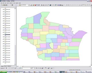
So I downloaded a bunch of files for the Wisconsin counties from the The Census 2000 TIGER/Line (linked from the ESRI site). The data for each county came in its own compressed folder with a shape file, as well as a .dbf and .shx file (which I wasn't really looking for). I had to uncompress each of the 72 folders and copy the shape file into another directory. Is there an easier way in windows? I know with linux/mac i could have a shell script do this!

Anyway, I then imported the shape files into ArcGIS and, lo and behold, up popped the state of Wisconsin with all the counties. Except ... I notice all the counties on the eastern side are not the correct shape. They're stretched horizontally. Is there a problem with the data? Do I need to tweak something in ArcGIS?


1 Comments:

At 2:38 PM, Blogger Greg Downey said...

Check the projection that's being used on the map. Setting map projections was mentioned in our last tutorial (though we didn't cover it in class).


Post a Comment

<< Home